EF8. What is El Niño?
Chapter 8
In the Peruvian hamlet of Chato Chico, after weeks of rain, Isaias Ipanaqué Silva watched the Piura River rising more than he had ever seen. Every several years, for as long as anyone in the village could remember, heavier than normal rainfall had come.
But never like this—five or six inches a day in some places.
On February 15, 1998, the river overflowed its banks and water entered the homes of Chato Chico villagers—first knee-deep and soon chest high. “Suddenly we were surrounded from all directions,” Silva said. “It took all the little animals. Then my house just fell down completely.”
Families struggled to save what they could. “In most cases,” said villager, Rosa Jovera Charo, “we just grabbed clothes for the children.” Everything else—chickens and goats, pots and pans, religious icons and personal treasures—washed away. Residents of Chato Chico were evacuated on barges, a few in helicopters, to a barren but dry refugee camp in the desert. Nearly all survived.
One hundred kilometers (60 miles) to the south, in the neighborhood of Motse outside the city of Chiclayo, Flora Ramirez said “We thought that the water couldn’t come here but we lost practically everything.” The neighborhood was flooded in minutes. “They strung ropes from one house to another to rescue people,” recalls Manuel Guevara Sanchez. “Some spent three days on the roof. Those who knew how to swim brought them food.” Ten people died out of a village of just 150.
Meantime, water flowing into the normally quite arid Sechura Desert suddenly formed the second largest lake in Peru: 145 kilometers (90 miles) long, 30 kilometers (20 miles) wide, and three meters (ten feet) deep. In some areas pooled water made perfect habitat for mosquitoes that caused rampant malaria—30,000 cases in the Piura region alone, three times the average for its 1.5 million residents.
Other places in the world had different problems that year. Smoke and soot from forest fires in Sumatra, Borneo, and Malaysia forced drivers to use their headlights at noon. The haze spread thousands of miles to the west to the Maldive Islands, where visibility was only half a mile at times. Heat waves caused temperatures to reach 42°C (108°F) in Mongolia, but Kenya’s rainfall was 100 centimeters (40 inches) above normal. Central Europe suffered record flooding that killed 55 in Poland and 60 in the Czech Republic. Indonesia had drought. Madagascar experienced monsoons and cyclones. Mudslides and flash floods hit communities from California to Mississippi and tornadoes ripped Florida.
But it all seems to have begun in the South Pacific off the coast of Peru. Every 3 to 7 years, a mass of hot seawater the size of Canada forms off the west coast of the Americas. It happens right around Christmas time, so fishermen called it El Niño, for the Christ Child. It is the source of giant storms that pour vast amounts of rain onto Peru’s normally arid northwestern coast and cause abnormal weather patterns across the equatorial Pacific and in turn around the globe.
It’s amazing that anomalies of ocean temperature can so drastically affect climate worldwide—temperature, air pressure, wind, humidity, rain, clouds, and ocean currents. The giant energy flow, El Niño of 1997-98, through unusually severe weather patterns around the world, killed an estimated 2,100 people, and caused at least $33 billion in property damage. It rose out of the tropical Pacific in late 1997, bearing more energy than a million Hiroshima bombs.
But wait. An El Niño winter is often followed by “La Niña”—where climate patterns and worldwide effects are, for the most part, the opposite of those produced by El Niño.
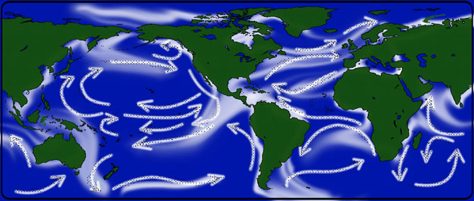
See the Animation, Perpetual Motion. Driven by wind and other forces, currents on the ocean surface cover our planet. Some span hundreds to thousands of miles across vast ocean basins in well-defined flows. Others are confined to particular regions and form slow-moving, circular pools. Seen from space, the circulating waters offer a study in both chaos and order. The visualization below, based on ocean temperature, salinity, sea surface height and sea ice data collected during field observations and by NASA satellites between July 2005 and December 2007, highlights many of the world’s most important ocean surface currents. Watch powerful, fast-moving currents like the Gulf Stream in the Atlantic Ocean and the Kuroshio in the Pacific Ocean carry warm waters northeastward at speeds greater than 4 mph. View coastal currents such as the Agulhas in the Southern Hemisphere transporting equatorial waters from the Indian Ocean farther southwards. Explore the image collection to compare the direction and unique flow pattern of each of these major currents. Animation from NASA GSFC Scientific Visualization Studio – http://svs.gsfc.nasa.gov/goto?10841.
I. What Causes El Niño?
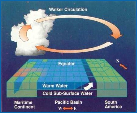
Under normal conditions, surface trade winds blow from east to west along the equator and pile warm water in the upper ocean of the western tropical Pacific near Indonesia and the Australian continent. The air above this warm mass of water is heated causing convection and precipitation. In the upper atmosphere, winds blow from west to east, completing a large scale atmospheric circulation known as the Walker Circulation (named after Sir Gilbert Walker who studied variations in the tropical Pacific atmosphere during the 1920’s). Often, the first sign that an El Niño event is underway is the appearance of unusually warm water off the coast of Ecuador and Peru, especially within a few months of Christmas.
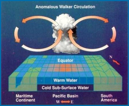
Every 3 to 5 years, an El Niño circulation happens in which the normal trade winds relax and the warm mass of water in the western Pacific can move east towards the South American continent. This shifts atmospheric convection and precipitation that was in the western Pacific (Asia/Australia) to the central and eastern Pacific, resulting in heavier than normal rains in northern Peru, Ecuador and other areas in tropical South America. In the western Pacific, with the mechanism for precipitation shut off, Indonesia and Australia can experience drought during an El Niño.
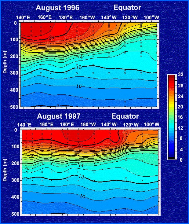
During 1996, the warmest water was about 30 degrees Celsius in the western Pacific and about 20 degrees Celsius at the surface in the eastern Pacific. During the 1997 El Niño, the warmest surface waters shifted to the central Pacific and the eastern Pacific surface waters warmed to over 25 degrees Celsius. [See Temperature Scales.]
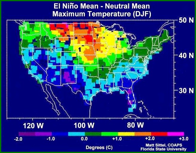
An El Niño produces alternating patterns of low and high pressure which can have major impact on weather far away from the equatorial Pacific. For North America, low pressure centered just to the southwest of Alaska and low pressure centered over the southeastern United States affects weather in western Canada, as well as the upper plains and southeastern regions of the United States.
Higher than normal temperatures occur in western Canada and the upper plains of the United States due to the low pressure system in the Pacific drawing warm air into Canada. Over the southern United States, another low pressure system draws cold moist air into that region bringing lower than normal temperatures.
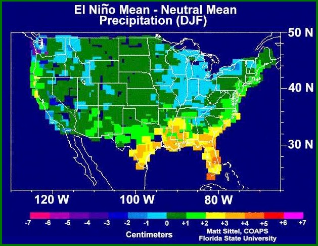
The same low pressure system in the southern United States is also responsible for increases in precipitation during an El Niño especially in those areas close to the Gulf of Mexico.
Precipitation in a year without El Niño…
and a year with El Niño….
II. La Niña
Where there was flooding there is drought, where winter weather was abnormally mild, it turns abnormally harsh. Fisherman might notice an unexpectedly high catch of sardines off the coast of Chile or tuna in the Gulf of Alaska. Lucky home owners might have to pay lower heating bills in some areas of the U.S.
Just as El Niño is caused by abnormal heating of water in the eastern Pacific, La Niña is caused by abnormal cooling of water in that same region. Like El Niño, the effects of La Niña happen most from December to March. Stronger than usual easterly wind from South America drives more than normal amounts of warm surface ocean water westward. This drives a larger than normal convection upwelling of cold water off the South American coast, producing a “cold tongue” of water that extends 4,800 kilometers (3,000 miles) westward along the Equator. It’s a revving of the Pacific’s mighty heat engine.
The warm water flowing toward Asia creates heavier monsoon rains in India, increased precipitation in Australia and as far west as southern Africa. Winter temperatures are warmer than normal in the Southeast U.S., and colder than normal in the northwest and upper midwestern states. That’s because the polar jet stream, which in an El Niño year stays high in Canada, moves farther south, driving frigid air down into the U.S. A subtropical jet stream flowing across Mexico and the Gulf during El Niño events weakens during La Niña causing less rain in the South and drought in the desert Southwest.
III. Economic Consequences
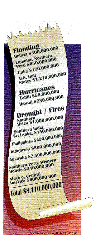
The economic consequences of El Niño can be staggering. Off the east coast of southern Africa, drought conditions often occur while El Niño is in progress. In countries such as Zimbabwe, whose economy is critically tied to maize production, the effects of drought can be devastating. Worldwide, over 8 billion dollars in damages can be directly attributed to the 1982 El Niño, which was the strongest such event recorded over the past 50 years.
Not all El Niño’s are the same, and the atmosphere does not always react the same way from one El Niño to another. Meteorologists and oceanographers continue to strive to understand the El Niño phenomenon and how it interacts with global weather. However, there is no convincing evidence to explain what causes the waters of the Eastern Pacific to become warmer or cooler than normal, starting the worldwide chain of weather events known as El Niño and La Niña.
There are many international efforts to predict El Niño events. At Goddard Space Flight Center, computer models of the atmosphere and the ocean are being developed and used in conjunction with satellite data for a better understanding of El Niño and how satellite observations can lead to reliable predictions of future Los Niños and the related effects on the ocean and atmosphere. With sufficient warning farmers and others can be prepared and damages from El Niño and the related weather changes can be minimized.
There are written records of El Niño’s effects in Peru at least as far back as 1525, and researchers have found geologic evidence of Los Niños in Peruvian coastal communities from at least 13,000 years ago. “We know the Inca knew about them,” says Adm. Giampietri Rojas of Peru’s Institute of the Sea. “They built their cities on the tops of hills, and the population kept stores of food in the mountains. If they built on the coast, it was not near rivers. That’s why so many of their dwellings are standing today.”
In western South America, farmers can benefit by planting more rice rather than a normal crop of cotton during an El Niño as they are likely to experience heavier than normal rainfall.
IV. Conclusion
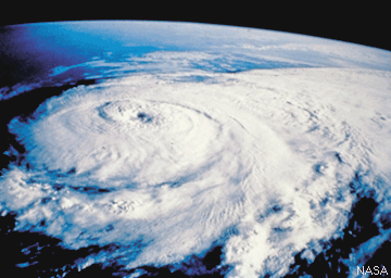
NASA photograph. http://hurricanes.noaa.gov/prepare/
El Ninõ and La Niña are only “abnormal” in the sense that they do not occur every year. However, they do occur on a longer cycle of every 3-5 years. Unlike global warming, which is probably a result of human activities, El Ninõ and La Niña are almost certainly due to natural causes.
It is very important for us to understand why these conditions occur so that we can better predict extreme weather around the globe, giving people time to prepare. The key to understanding and prediction involves understanding how energy flows through Earth systems.
NOAA launched its El Niño & La Niña web page 2016 Feb 3 – https://www.climate.gov/enso
In the next chapter we’ll see how energy flows through living systems.

